
Terradepth CEO talks about a project to map out and collect data from all the oceans of the world. The company uses artificial intelligence and machine learning to gather and make sense of the data.
TechRepublic's Karen Roby spoke with Joe Wolfel, co-CEO of Terradepth, about the company's ocean data-collection robot. The following is an edited transcript of their conversation.
Karen Roby: I think this is a good way to summarize that what you guys are doing and are working toward is a fleet of fully autonomous deep ocean data collection submarines. Tell us a little bit about how this came about? I mean, you don't just wake up one day and say, yeah this is what I think I'm going to do. I mean, this has been a whole lifetime of work I guess, that's feeding into this.
Joe Wolfel: It has been a long time in the making. So my co-founder and I met in the Navy, actually, in 2004. So, it's been a while in the works, but we met there and kind of started to understand how really little humanity understands about the ocean. And that idea set in the back of our heads since then. And so finally, we got to a position where we were able to start Terradepth and here we are.
Karen Roby: When you say humans, that we know so little, I mean, how much do we really know? I mean, there's so vast the amount to cover there.
Joe Wolfel: The ocean encompasses about 70% of the planet's surface area, and that's a number you hear a lot. You also hear that we know more about the surface of Mars than we do about the ocean, which is also a fact. But a number that people don't really think about too much is 98.5. And 98.5% is actually the amount of Earth's biosphere that is comprised of the ocean. And so that's all the livable space on the planet. And so 98 and a half per cent of that is the ocean. And the ocean just attenuates signals so badly that you can't fly satellite constellations over it and get all this data that we can in the terrestrial world. Right? So that means you need to be in the ocean to get that data in situ, as we say, which drives a whole set of technical hurdles and challenges that you really need to overcome. If you're going to increase humanity's understanding of what we call the final frontier action.
Karen Roby: We talk about collecting data and I can't imagine, I mean, there's got to be a wealth of things down there that you want to study. Talk a little bit about the things that you hope to look at and what all would be involved here.
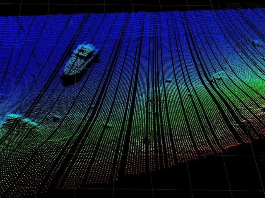
Joe Wolfel: The ultimate vision of Terradepth is to really complete what the Google Earth initiative started. Google Earth started and we've got very high-resolution maps of the terrestrial environment, but we don't really have good ones of the ocean. A lot of the bathymetry, the typology of the seabed that you see on, say, Google Earth, is really extrapolated data from satellites where the satellite say, "OK, well, this is the way that the surface of the ocean is behaving, so there must be something of gravitational importance down there." This is why you have the U.S. Navy submarines running into mountains, like what happened in 2005. So, a major effort at Terradepth is to gain bathymetry on a scale so that we really understand what the bottom of the seabed looks like to a high degree, enough of resolution that we can make good decisions about what's down there.
Joe Wolfel: But, part of a Terradepth data collection story is really much broader than that, right? Because we're going to be going into this very hostile remote environment. So, we want to get all the data that we possibly can. We've designed a way to provide high energy at sea to the robot so that we can have a multitude of sensors. So, instead of just bathymetric data, now we're talking about getting chemical data, environmental DNA data, optical data and others. So, really we're just limited by the amount of energy we can deliver to that sensor payload on the robot.
Karen Roby: When you talk about that amount of data, Joe, obviously more than humans, when that information is back here to us, can actually go through, I mean, artificial intelligence playing a big role, machine learning here.
Joe Wolfel: Correct. AI and machine learning actually plays a role in both our data collection operation and on the back end when the user is going to interact with the ocean data. Our first major milestone really was proving that we could do an advanced at a high degree of edge compute on the robot in the water all inside of a pressure vessel, really. We've worked on two machine learning models that we run simultaneously in that data processing pipeline. What that allows is for the robot to go do a surveying mission and then making inferences about what it saw, whether it's an object of importance or a region of importance. And then go back and resurvey for greater fidelity on that data that it collected the first time, all autonomously with no human in the loop in that operation. So that's where AI/ML plays a role in the robot. But then also when you're dealing, to your point, Karen, with these terabytes of data that are coming back, we've also taken a hard look at how to reduce human cognitive load while you're looking for things that are important, right? We're using those machine learning models then to flag human interests in the cloud.
Karen Roby: Joe, you mentioned that major milestone too, just getting over that. Where do you stand in terms of the trials and what type of timeline are you looking at now?
Joe Wolfel: Backing up a little bit. The first thing that you really need to do to scale ocean data is making the robot really smart. Right? So, that's the thing that we just proved. But it doesn't matter if your robot is really smart if your robot can't stay out for a very long time without humans interacting with it. Right. If you're going to be recovering this robot every day, two, three days, it's just unscalable, especially with 310 million square kilometres of ocean that needs surveying.
So, the next major milestone will be placing an energy recharge system, a fully autonomous energy recharge system in the submersible, and then making sure that we've got a really smart robot. And now we've got a really smart robot that can stay out for a very long amount of time because we can autonomously recharge our batteries to continue doing data collection operations. We anticipate that test will be done sometime in the next 90 to 120 days. At which point we'll have proven us, we call it the con-op, the concept of operations at Terradepth, which is really the key we think to have a scalable ocean data collection capability.
Karen Roby: Joe, going from being a Navy SEAL and then now to bringing this dream to life, I mean that's really fascinating how you've gone from that to now this and really going to be great to see how it takes off.
Joe Wolfel: Thanks. We're excited. We got a great team doing both the data collection piece and the data utilization and interaction side of the house. It's a complex strategy that we're running here, but we've got a great team who's helping us along the way, getting it done.
by Karen Roby (TechRepublic)