
Crop evapotranspiration assessment under climate change in the Pannonian basin during 1991–2050
(An excerpt from the paper Nistor et al., 2017)
Food resources and cultivated areas are one of the priorities of the development and sustainability agenda for humanity’s future. Even if the globe is an endless source of food, the costs and good management of territories make a real difference between many agricultural regions of the world. In this scenario, the best areas are those that exhibit the most favourable conditions in terms of adequate climate for agriculture, morphological characteristics and fertile soils. Almost all agricultural lands and eco-regions need to preserve future functionality. Being a primary good that impacts society, agriculture and transportation, water represents the most valuable resource on a regional scale (Jiménez Cisneros et al., 2014). Hence, the quantity of available water is an important measure for recent climate change (Shahgedanova et al., 2005).
The present climate is warming (Shaver et al., 2000; Oerlemans, 2005; Dong et al., 2013; Xie et al., 2013) and, for the 21st Century, increases in average temperatures on one side and decreases in precipitation rates were announced (Stocks et al., 1998; IPCC, 2001; Stavig et al., 2005). Climate change is easily observed between different regions, e.g. the Alps range and Carpathians range, Pannonia plain and Po plain. In this work, climate data on precipitation, temperature and actual evapotranspiration together with Corine Land Cover 2006 are the main datasets that were taken into account. Boegh et al. (2009) created a model of water balance, considering the evapotranspiration and runoff modelling of main land cover types for Sjaelland Island, Denmark.
Recently, Mojid et al. (2015) argued that climate change impacts crop water demand. Pravalie (2014) and IPCC (2007) recall that evapotranspiration on a global scale is related to the trend in temperature and other complex factors of anthropogenic nature. As previously mentioned by Chen et al. (2006) and Kousari et al. (2013) reported that evapotranspiration is the third important climatic factor that controls terrestrial ecosystems and the atmosphere mass exchange. Thus, the assessment of crop evapotranspiration (ETc) becomes a significant indicator that is commonly used in regional water balance and irrigation surveys. Kurnik et al. (2014), in their study of water deficit in agricultural regions of Europe, created a soil water balance model that included simulations of soil water deficit and actual evapotranspiration. The assessment of sensitive parameters using different evapotranspiration methods was attempted by Ambas and Baltas (2012) in the Prefecture of Florina, Western Macedonia. Nistor and Porumb-Ghiurco (2015) applied the geographical information system (GIS) applications and empirical formulae to calculate the land cover evapotranspiration on a regional scale. Recently, Nistor (2016) used GIS to compute the spatial distribution of climate indices in the Emilia-Romagna region. Thus, the present methodology was adopted from similar studies related to crop evapotranspiration (ETc) in the Emilia-Romagna region (Nistor and Porumb-Ghiurco, 2015) and the Carpathian region of Europe (Nistor et al., 2016).
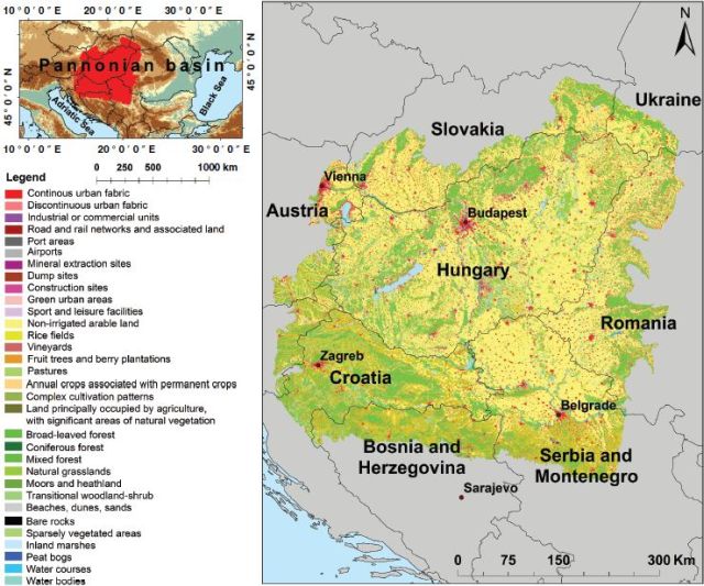
Figure 1. Location of the Pannonian basin on the Europe map (a) and land cover of the Pannonian basin (b)
Study area
The Pannonian basin is located in the central part of Europe, between 43°50 ' and 49°15' latitude N and 15°06' and 23°30' longitude E (Figure 1). The region largely overlaps with the Pannonian plain and extends over nine countries: Austria, Slovenia, Hungary, Croatia, Bosnia-Herzegovina, Serbia and Montenegro, Romania, Slovakia and Ukraine. The physical characteristics of the Pannonian basin are the low land including the Great Hungarian Plain, the Danube plain, the Sava plain and the Drava plain (European Environment Agency, 2007). The surroundings of this region are bounded by the Alps range in the west, by the Carpathians in the north and east and by the Dinarics in the south.
As far as the climate is concerned, the Pannonian basin is characterized as fully humid Cfa in the southeastern part of the region and Cfb in most of the territory (Kottek et al., 2006). The Cfb climate class is characterized by a fully humid climate with warm summers (Kottek et al., 2006). The Pannonian basin has a Dfb climate near the Carpathian mountains in the northeastern side and on the western side close to the Alps. The Dfb climate class represents a humid continental climate, characterized by fully humid seasons with warm summers and cold winters (Kottek et al., 2006). The precipitation ranges from 400mmin the eastern part to 1800mm in the western part. The highest annual temperature of the Pannonian basin is up to 12.64 °C in the south-central parts of the region and displays the lowest values in the northern part of the region. The potential evapotranspiration (ET0) ranges from 586 to 739 mm. The average precipitation, temperature and ET0 climate data relative to the recent period (1991–2020) and future period (2021–2050) are shown in Figure 2.
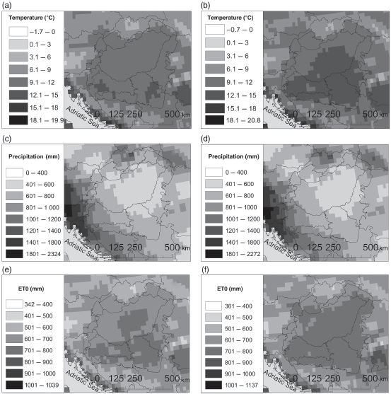
Figure 2. (a) The mean annual air temperature between 1991 and 2020. (b) The average mean annual air temperature between 2021 and 2050. (c) The average mean annual precipitation between 1991 and 2020. (d) The average mean annual precipitation between 2021 and 2050. (e) The average annual ET0 between 1991 and 2020. (f) The average annual ET0 between 2021 and 2050.
The main types of soils found in the study area are chernozems and black soils rich in humus (European Environment Agency, 2007), characterizing the Pannonian basin as an important agricultural land in central Europe. The widespread land cover area is represented by grass, pasture, agricultural area and forest. The forest land includes the main species of oak (Quercus), beech (Fagus), elm (Ulmus) and hornbeam (Carpinus) (European Environment Agency, 2007).
Conclusions
The main aim of the study was to calculate crop evapotranspiration ((ETc) in the Pannonian basin for the present and future periods. Even if the goals were achieved, limitations come from overlapping growth of each land cover type. The complex cultivation period data of the Pannonian basin is hard to integrate into four stages because the real situation requires more overlaps between crop growth. Nistor and Porumb (2015) explain very well how to evaluate the ETc at the regional level, applying the same methodology to the data relative to the Emilia-Romagna region in Italy.
The work presented here shows how to assess the ETc at the space level using the land cover database and climatological spatial data. The methods should be improved with specific file measurements, to be closer to the real situation. Climate changes mostly contribute to the distribution of evapotranspiration in the Pannonian Basin. The work applies well to the management and assessment of water resources in agricultural lands. The future scenario shows howETc in the Pannonian basin will evolve under climate change during 2021–2050. Several places from the south and southwestern sides of the region with values of annual ETc exceeding 1000mm were found. The findings are useful to agriculture planning, climatology of the Pannonian basin and for identification of critical water areas and irrigation demand areas. In the future, the focus will be on the projection of land cover, not only on scenarios related to climate data. The results may be useful in the calculation of groundwater vulnerability of the area under climate change.
Margarit-Mircea Nistor, Sorin Cheval, Alessandro F. Gualtieri, Alexandru Dumitrescu, Vanessa E. Botan, Alex Berni, Gheorghe Hognogi, Ioan A. Irimu and Cosmin G. Porumb-Ghiurco (2017) Crop evapotranspiration assessment under climate change in the Pannonian basin during 1991–2050. Meteorol. Appl. 24: 84-91
You can find the whole paper at this address:
https://rmets.onlinelibrary.wiley.com/doi/full/10.1002/met.1607